River Restoration – The dynamics of reconnecting our waterways
- Dec 14, 2023
- 4 min read
Updated: Jul 4, 2024
by Marcell Szabó-Mészáros
Marcell is a Scientific Associate at the Department of Water Engineering and Water Management, Budapest University of Technology and Economics. He works as part of a team of scientists and researchers focused on water flow dynamics, sediment transport, water quality and biota in the Danube River. This knowlege base will underpin decision making towards the planning of river restoration activities included in DANUBE4all, as well as make a significant contribution at a wider level to policy making and river management for the region.

Free-flowing rivers have been roaming the earth for millions of years. They are instrumental in forming landscapes, influencing local climates and providing water for nature to thrive. Since pre-historic times, humanity has relied heavily on these bountiful natural resources for water and food, and the role and functionality of rivers has been evolving throughout the millenia in tandem with human development.
Civilizations have always benefited from the presence of freshwater and have long harnessed the raw power of rivers to secure land and water resources in support of growing populations and societies. Since the industrial age, the rate and scale of human exploitation and adaptation of rivers has intensified enormously. Decades of river regulations and planning have overseen the large scale alteration of waterways for navigation and paved the way for the conversion of huge tracts of natural watercourse floodplains into living places and agricultural land. As population pressures have increased, so too has the pressure we exert on our river systems in adapting them for our needs.
River connectivity
Antropogenic interventions i.e., changes which occur as a result of human activities, transform the natural course of a river over time. The results are reductions in vital floodplain areas and the breaking down of a river’s natural ‘connectivity’ along its network.
River connectivity refers to the degree to which water, sediments and aquatic life can move freely along the length, breadth, and vertical dimensions of a river.
There are four different types of connectivity that we may differentiate:
Longitudinal connectivity – free transportation of flow and sediment downstream and the free movement of aquatic organisms both upstream and downstream along the river
Lateral connectivity – free flow transversally (across the river) within the floodplain. This provides the natural transportation of nutrients between the main stem and the floodplain, while integrating vital habitats for riverine flora and fauna
Vertical connectivity – the linkage between the free surface watercourse (river) and the subsurface (groundwater) through the natural, permeable hyporheic zone*.
Temporal connectivity – the dynamics of the aforementioned three spatial connectivities in time, for example seasonal changes, and annual or multi-year floods.

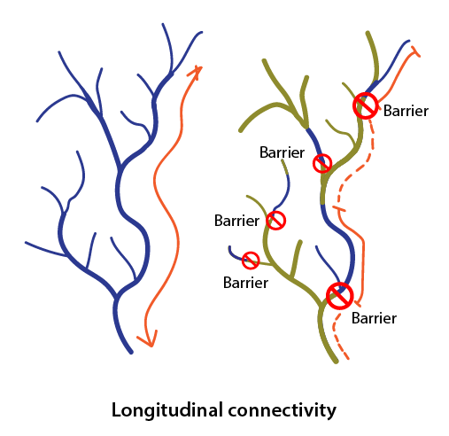

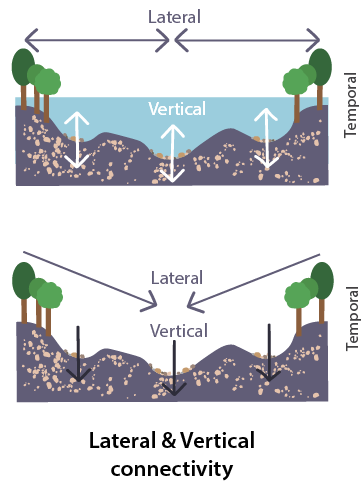
Illustrations modified from the study of Allen et al (2020)
*The Hyporheic zone [hi-por-ay-ic] is an area under a river or stream where the river water mixes with the ground water. Water from the river can cycle in and out of the hyporheic zone, which acts as a kind of natural water filter, cleaning it before cycling it back into the channel.
Source: GIF courtesy of Wiki Commons
Barriers to connectivity
Man-made barriers are often the biggest threat to river connectivity as they negatively affect key system processes such as fish migration and sediment transport. Man-made barriers come in the form of dams, weirs, groynes, culverts, fords and locks, among others.
Dams, most commonly built for irrigation, navigation or electricity production, are the most visible and impactful transversal river barriers we have. These structures fragment the longitudinal connectivity of the river’s natural processes and transform ecosystems for plant and aquatic life, both up and downstream of their location. Some of the changes, such as disturbances to fish migration, are evident right after dam construction; other processes such as altered sedimentation transport along the river, take more time.
Restoration actions
Over the last decades in particular, society has become increasingly aware of and concerned with the ecological toll of industrial development and our heavy focus on economic growth. In response to the well-documented environmental challenges we face; societal, public, and scientific actions have become more focused on the preservation, conservation and restoration of ecological services on a growing scale.
Restoration actions in these once natural, now heavily populated landscapes are usually highly challenging. Thus, there is an urgent need for research to understand what needs to be prioritized ecologically, while we mitigate the legacy of historical river regulations and our approach to river manangement.
There have been several EU-funded initiatives addressing selected connectivity issues of river regulations. Most notable among these are the AMBER, DanubeSediment and DOORS projects. As a European Lighthouse project, DANUBE4all builds on this work and expands the focus to address multi-dimensional connectivity for the Danube and its main tributaries across its river basin.
A crucial part of this effort is the mapping of the current status of longitudinal and lateral connectivity on the river network for the movement of fish and sediment transportation.
Over its five-year lifespan, the project will also demonstrate the use of technical solutions at the three research sites on the Danube, while providing a catalogue of restoration measures that are beneficial for both ecology and society. Importantly, the project aims to achieve these ambitious measures via transboundary, multi-stakeholder efforts that will bring together scientists, researchers, SMEs, investors, public bodies, policymakers, and local communities.